Spatial data science for sustainable development course introduces geographical and computational analysis approaches to study sustainability related questions. The course is inspired by the United Nation’s 2030 Agenda for Sustainable Development and the Global Sustainable Development Report, as well as numerous scientific articles that have investigated sustainability related problems through the lense of geospatial analytics. Spatial data science provides various methodologies that are useful to understand, model and quantify different sustainability related phenomena. Both sustainability and spatial data science are enormous fields on their own, hence it is only possible to scratch the surface of both of these worlds. The selected themes are also biased towards topics that the authors are familiar with. Due to these reasons, unfortunately, many important topics cannot be covered during the course. The course has been developed at the Department of Built Environment, Aalto University, Finland, and the materials are openly available for anyone interested.
After completing this course, you should:
understand and deepen your knowledge of a range of modern spatial data science (SDS) techniques and methodologies
be able to apply SDS methodologies in practice to a range of sustainability/global change related topics with Python programming language
have skills and understanding how to retrieve, handle and analyze modern big geospatial data in different formats.
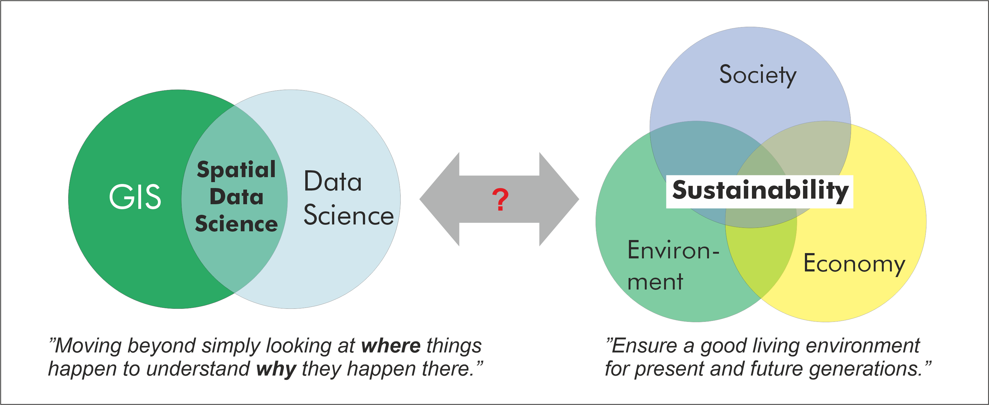
Two main components of the course: Spatial Data Science & Sustainable Development.#
Prerequirements
Before taking this course, it is required to know the basics of Python programming as well as GIS. If you are new to Python, or would like to refresh your Python skills, we recommend to start with an online and open access course called Geo-Python which is available at geo-python.github.io. If you need to refresh your Python GIS skills, we recommend starting with a course Automating GIS-processes and Spatial analytics. All of these courses include tutorials, videos and exercises.
Help improving the materials
This is version #6.
The course was given for the very first time in 2021. It is likely that the contents will
change and improve after each iteration (all versions will be available). By being a fully open
educational resource, you can also help making the course better.
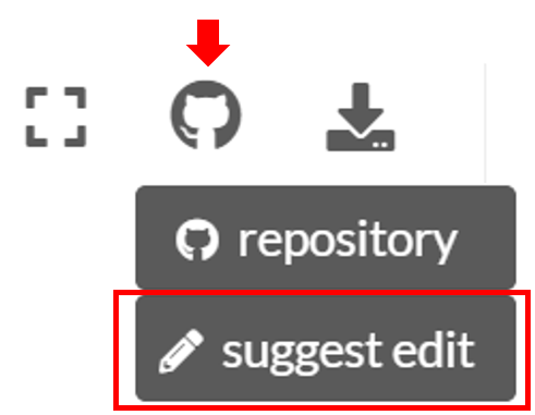
If you find any errors, typos, or other problems, please help, by suggesting an edit in GitHub. You can do this easily by clicking
suggest edit under the GitHub icon located at
the top-right on each page:
If you have good ideas about what should be taught, i.e. what methods, interesting datasets or literature should be introduced during the course, you can suggest and bring your ideas forward by raising an issue in GitHub.
Course format#
The majority of this course will be spent in front of a computer writing code with the Python language. The course consists of lectures, tutorials and weekly exercises. The exercises will focus on applying the introduced SDS methods to given sustainability related problem, and writing short essays about the given sustainability topic introduced during each week.
Most exercises in this course involve real world examples and data. For each exercise, you may be asked to submit the Python codes you have written, output figures and answers to related questions. You are encouraged to discuss and work together with other students while working on the weekly exercises. The final exercise must be completed individually and must clearly reflect your own work (in short, don’t copy paste from other students).
Aalto University students
The Spatial Data Science for Sustainable Development course is part of the
Master’s Programme in Geoinformatics at Aalto University
under the course code GIS-E4040.
Interactive contents
Each lesson in this course can be turned into an interactive programming session in the browser. You can find buttons for activating the python environment using Binder at the top of each programming lesson. Students at Finnish higher education institutions are encouraged to use the CSC Noppe environment.
Program#
The course runs for six weeks at the Aalto University starting in the third teaching period. Each week covers selected spatial data science (SDS) methodologies which are applied to topics/problems relevant for selected sustainable development goals (SDG). Topics per week are listed below. Please note that this web page is updated each week before the lesson:
Week |
SDS themes |
SDG themes |
|---|---|---|
1 |
|
|
2 |
|
|
3 |
|
|
4 |
|
|
5 |
|
|
6 |
|
|
Contents#
Course information
Exercises
Final Assignment
Tutorials
Week 1
Week 2
Week 4